Fleet tracking software Australia
Fleet tracking AU operators trust, with up-to-the-second GPS vehicle positions, trip replay and geofencing alerts. Run tracking devices across your whole mixed fleet to cut wasted kilometres and lift schedule performance across Australia.


Run Your Whole Fleet From One Screen
- See every vehicle live: cars, vans and trucks on one Crystal map, updated every 10 to 60 seconds.
- Cut wasted kilometres and fuel: trip history and geofencing expose idle time, long detours and unverified stops.
- Recover a stolen vehicle faster: the GPS unit keeps reporting position when the ignition is cut.
- Prove every job and trip: timestamped, GPS-anchored history settles disputes and backs your billing and audits.
- One platform, the whole fleet: tracking, maintenance, safety and compliance under one login, ten vehicles or ten thousand.
Book a Demo
Review Ctrack fleet tracking in a personalised demo to see GPS tracking, geofencing and trip replay across your whole fleet.
Fleet tracking software and GPS vehicle tracking
Fleet vehicle tracking puts a GPS device in each vehicle and uses the global positioning system to report its location and movement on one map. With Ctrack Crystal you get the position of every car, van and truck as it happens, plus trip history, geofence alerts and driver behaviour, fuel and idle data behind it. It extends beyond tracking a single van: where vehicle tracking covers one unit, this runs the whole mixed fleet from a single login and feeds straight into your fleet management solution. GPS technology turns scattered vehicle location into one operating picture for fleet operators.
End manual location chasing
Today, dispatchers and the fleet manager ring drivers for updates and ETAs, which slows response times and frustrates customers waiting on a job. Real-time tracking answers it on the map instead.
Detect route deviations early
Unplanned stops and detours go unnoticed until costs rise. Non-productive idling alone wastes around 7% of fuel, an EROAD benchmark. Exception alerts surface the problem the day it happens.
Close utilisation blind spots
Without fleet utilisation reporting you cannot see which units are underused, overworked or sitting idle. Fleet data stays buried in spreadsheets and performance suffers. A way to monitor fleet activity turns it into a daily view.
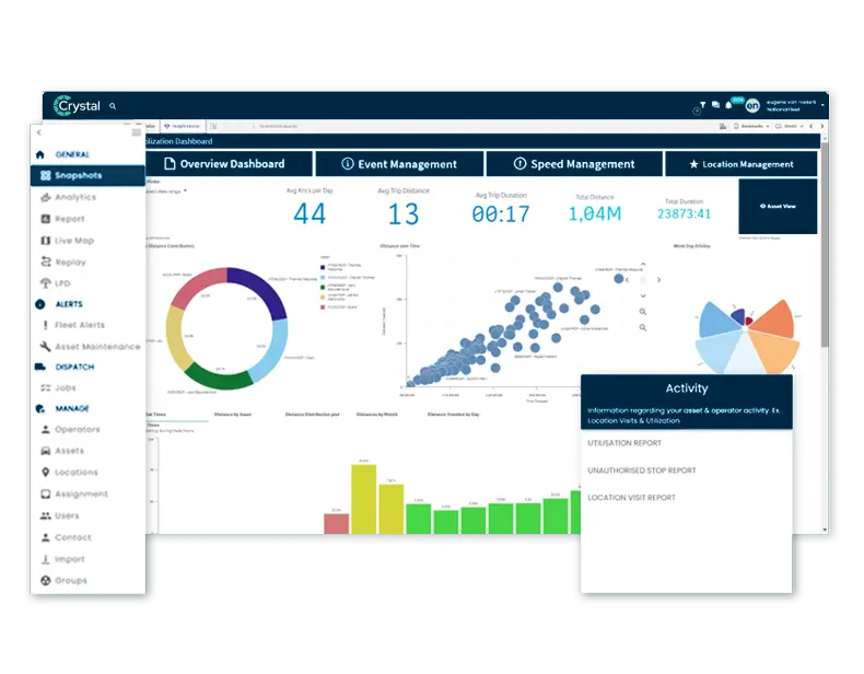
Real-time fleet tracking software features
Crystal turns location data into decisions your team can act on across dispatch, operations, maintenance and leadership. Four capabilities lead the platform: map visibility, trip replay with exceptions, geofence alerts and utilisation reporting, all in the base tier. Add fleet analytics, fleet safety tooling and compliance modules on the same login as you grow into a full telematics solution.
Real-time location tracking with status, movement and job context. See every vehicle as it moves, from any device.
Replay routes, stops and timelines from each GPS tracking device to verify service delivery. Generate evidence for disputes or compliance audits.
Virtual boundaries for depots, customer sites and no-go zones, drawn straight onto the GPS system. Automated entry/exit notifications keep controllers informed.
Understand time on task, idle patterns, and asset use. Identify underperforming units and reassign work based on actual usage data.
Fleet tracking system data workflow
The system moves data from the device to the platform to your team in three steps, with no manual entry. A GPS unit captures location, the cellular network carries it to Crystal, and dispatch acts on it from one map. Around 49% of large Australian fleets already run telematics this way (AfMA).
1. Fit the tracking hardware
A rugged, small-form-factor hardwired GPS tracker goes into powered cars, vans, trucks and plant. A battery-powered vehicle tracking device goes onto non-powered trailers, containers and gear. Optional add-ons include cameras, driver ID, temperature and CAN-bus diagnostics. Each unit captures position continuously.
2. Data streams to the platform
Location, trips, stops, geofence events and exceptions stream securely to Crystal every 10 to 60 seconds. When a vehicle drops out of coverage on a remote run, the unit buffers the trip offline and uploads it automatically on reconnect, so nothing is lost.
3. Act on it from one map
Dispatch sees every vehicle's location, status and ETA in one view, so monitoring and tracking happen in the same place. Geofences fire arrival and departure signals, speed and idle alerts surface coaching opportunities, trip replay settles disputes, and scheduled reports land in the inbox.
Map visibility for every fleet vehicle
Real time fleet tracking shows which units are moving, idle, on-site or off-route, and gives accurate ETAs without calling drivers. GPS vehicle tracking on a single vehicle tracking system is where the value starts: one screen for the whole operation, updated as each unit moves, with the tracking technology doing the work in the background.
- Whole-fleet view with filters by team, region, job type, or vehicle class.
- Automatic arrival/departure signals via geofences.
- Trip replay to resolve disputes and verify time-on-site.
- Speed and idle alerts for proactive driver coaching.
- Scheduled and exception-based reports delivered to your inbox daily or weekly.
Commercial fleet tracking by industry
It supports transport, delivery and field service fleet operations with the workflows each one needs for day-to-day control. From truck fleet tracking on long-haul runs to 10 vans on metro drops or 500-plus assets across sites, these vehicle tracking solutions scale with you, with the same tracking services and asset tracking behind every job.
Transport & logistics
Trip replay, exception workflows, and compliance-ready records for long-haul and metro operations. Chain of Responsibility and Electronic Work Diary integration built in.

Distribution & delivery
Accurate ETAs, job oversight, and arrival/departure proof for multi-drop operations. Reduce missed delivery windows with up-to-the-minute dispatch updates.
Field services
Dispatch the nearest technician and verify time-on-site with location history and geofences. Improve first-time fix rates by getting the right crew to each job faster.
Fleet tracking solution ROI benchmarks
These are industry benchmarks, not inflated claims. Use them to frame a pilot, then validate the result against your own baseline. The benefits of fleet tracking show up as fewer wasted kilometres, less idle, better utilisation and faster recovery of a stolen asset. Modern fleet tracking systems make those gains measurable instead of anecdotal.
Operational benchmarks
Use these benchmarks to frame your pilot. Validate results against your own baseline KPIs before rollout.
Fleet tracking for Australian fleets with Ctrack
What Australian fleets rely on comes down to hardware that holds up, data that stays local and a support team that knows AU regulation. Ctrack has delivered that capability since 1985.
Built for Australian conditions
Offline buffering keeps recording through coverage blackspots on remote and regional runs and syncs on reconnect, so the trip record stays intact where consumer-grade trackers go dark. Data is held in Australian-hosted data centres.
One platform, one support contact
Ctrack owns the hardware, firmware, software and support, on a TCA Type-Approved platform. This fleet tracking system provides AI video, CoR and EWD compliance, fuel and utilisation analytics on the same login, so tracking, cameras and compliance grow together without re-platforming.
Proven and protected
40-plus years, 300,000-plus subscriptions globally and over 1 billion km tracked per month, with ISO 27001 and 24/7 local support. As vehicle tracking software backed by GPS tracking systems, it recovers tracked vehicles at about 72% in Australia (NMVTRC), against far lower rates for untracked ones.
Fleet tracking devices for cars, vans and trucks
A hardwired fleet tracking device suits powered fleet vehicles and battery trackers suit non-powered assets, from 1 vehicle to 1000-plus. The TX650 is the TCA Type-Approved regulatory-grade unit. GPS fleet tracking devices report into the same platform, so one fleet tracker can sit beside a heavy-vehicle unit on the same map. Compare the trackers to match each asset to the right unit, whether you run light vans or regulated heavy GPS fleet tracking systems.
Fleet Visibility
Crystal puts every vehicle on one live map: location, status and accurate ETAs in a single view. Dispatch answers customer questions and spots an exception without ringing a driver, so the blind spots between jobs close up.
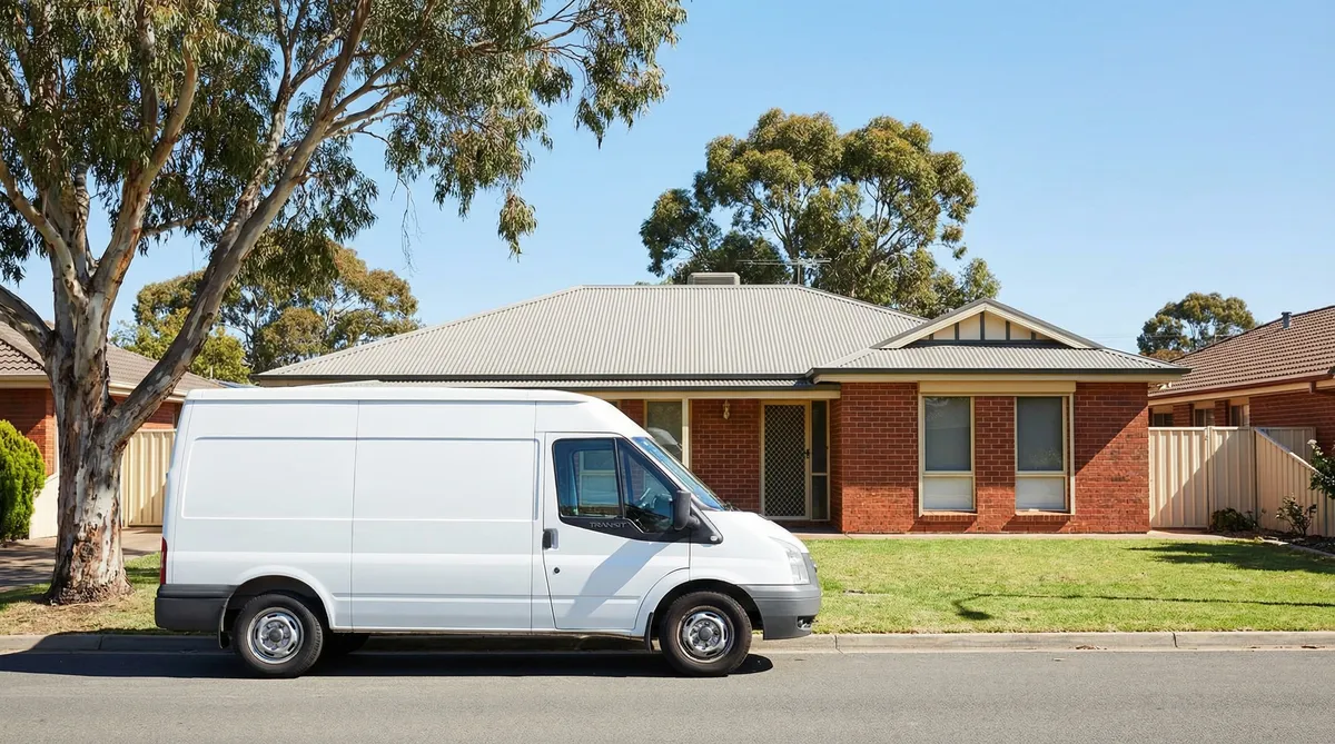
Mixed Fleet Tracking
Cars, vans, trucks, plant and trailers run on one platform with one asset inventory, instead of a separate system for each vehicle type. Hardwired units cover powered vehicles and battery trackers cover non-powered gear, all in the same view.
Remote Fleet Management
Offline buffering keeps recording where mobile coverage drops on remote and regional runs, then syncs the trip the moment it reconnects. Low-power links such as LTE-M and NB-IoT suit long-life units in the field, so nothing is lost on a remote route.
Fleet tracking solutions: questions answered
Practical answers for operations, compliance and procurement teams.
Tracking is the entry point. Ctrack's GPS fleet tracking software is one of several capabilities on the platform, so move up to the management hub or out to the GPS fleet tracking solutions that sit alongside it.
The hub above tracking: maintenance, safety and compliance on the same platform.
Track devices, vans and trucks down to the single unit, with the same Crystal map.
Turn tracking data into utilisation, cost and behaviour reporting for leadership.